Thursday, November 6, 2014

An Important 19th Century Hoosier Highway: Michigan Road

A restored section of the in the town of Delph...
A restored section of the in the town of Delphi in . Photo looks northeast from Washington Street. (Photo credit: Wikipedia)
The St. Joseph River widens as it flows west t...
The St. Joseph River widens as it flows west through Elkhart. (Photo credit: Wikipedia)
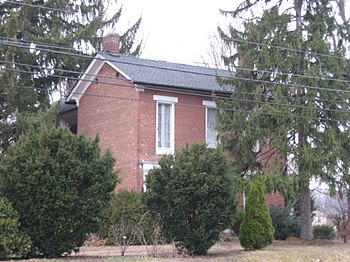
English: Front of the , located at 6620 N. Mic...
English: Front of the , located at 6620 N. Michigan Road in , , . Built in 1852, it is listed on the . (Photo credit: Wikipedia)
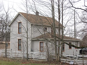
English: Side and rear of the , located at 470...
English: Side and rear of the , located at 4702 N. Michigan Road in , , . Built in 1866, it is listed on the . (Photo credit: Wikipedia)
When Indiana became a state in 1816 it lacked a passable road system. The few roads that did exist were roads in name only. One of the first roads that existed in Indiana was called Buffalo Trace. It was bullet on an abandoned Bison trail that connected the sparely populated areas between New Albany and Vincennes. In 1829 the National Road (Old Route 40) connected Indiana to the populated eastern states.. There were few roads leading to and from Indianapolis. The National Road opened up the state to travelers coming from the east to the west.
The National Road started in Maryland and ended in Stylus Missouri which was the gateway to west for early settlers. This was the only major road in Indiana at the time that could be traveled on all year. It was covered with a thick layer of gravel
The National Road went through Richmond to the new state capital Indianapolis and ended at Terre Haute. Indiana now wanted a road that connected the cities of the state North and South. The new road was to be called Michigan Road.
In 1826 the Pottawatomie Indians gave up land by signing Mississinawa Treaty that would make possible a road to run from the Ohio River in the south to Lake Michigan in the north. The long established river town of Madison Indiana was to be the most southern town on the route.
A state commission in 1828 selected the route from Indianapolis to Lake Michigan. The trail head of road was to be a harbor in Lake Michigan. Surveying for the road began in 1828 and most of the road was completed by 1834.
The major flaw of the original plan was it did not consider some natural obstacle to a straight route .The Kankakee Swamp prevented a straight north south route. It was finally decided to direct the road more northwesterly and have it travel straight north from the already established transportation hub at Logansport Indiana. The road went straight all the way to the south bend of the Saint Joseph river (now South Bend Indiana) and then west to Michigan City and Lake Michigan.
The southern branch of Michigan Road was much straighter .From Madison Indiana Michigan Road went to Greensburg Indiana and from there straight to Indianapolis. It was the most traveled route for almost anyone going to Indianapolis from 34 counties even if the road itself only ran through 14 Indiana counties. In 1836 the state decided to pass a bill called the Mammoth Internal Improvement Act and to pave the entire Michigan Road. The Panic of 1837 caused the state never to fund the paving of Michigan road and control of the road improvements fell on the shoulders of the various counties that the road ran through
Michigan Road opened up commerce to move thorough out the state from the Ohio River to the new state capital at Indianapolis. Many towns grew up along Michigan Road to serve the ever increasing numbers of settlers traveling through the state. It was not an easy journey for people who traveled along the Michigan Road. It made its way through small swamps and forest streams cluttered with underbrush and forest debris from frequent storms. Rocky stretches of the road were with filled with ruts made travel impossible at times on the road.
Michigan Road was only truly passable during the summer and early months of fall. Snow and rain made the road nothing but a large muddy river during much of the rest of the year. Travel in the winter could be made impossible by the frequent snow storms common in the northern part of the state. For settlers who waited for the road to freeze to make travel easier and stopped on the way to wait out the blizzards; it must have been frustrating to stop again too wait out the muddy mess made by Indiana's many unexpected spring thaws.
None of the hardships of travel on Michigan road stopped the thousand of settlers from using it. The road became less traveled with the advent of the railroads and inexpensive steamboat travel. Much of the original Michigan road can be traveled today. Many of the towns that existed on Michigan Road went from vibrant settler boom towns to sleepy Indiana rural villages. Michigan Road enjoyed a bit of a comeback with popularity of car travel before interstate system. It then again became the scenic route for those who wanted to travel the state north to south at a slower pace. There is much of the original roadside architecture is still standing today along the now road less traveled; called Michigan Rd.

The story of Michigan Road in Indiana is much like the early story of Indiana history. The road lived a brief life as a conduit for settlers to enter a wild sometimes dangerous world in hopes of a better life only to become a main country road traveling through moderately prosperous sleepy Victorian towns and well kept family farms. The history of Michigan Road took a brief thirty years to make this tremendous transformation happen..

No comments:

Post a Comment